Robohub.org
No GPS, no problem: Next-generation navigation

Simulation results for a unmanned drone flying over downtown Los Angeles showing the true trajectory (red line), from GPS only (yellow line), and GPS aided with cellular signals (blue line). Image: ASPIN Laboratory at UC Riverside
A team of researchers at the University of California, Riverside has developed a highly reliable and accurate navigation system that exploits existing environmental signals such as cellular and Wi-Fi, rather than the Global Positioning System (GPS). The technology can be used as a standalone alternative to GPS, or complement current GPS-based systems to enable highly reliable, consistent, and tamper-proof navigation. The technology could be used to develop navigation systems that meet the stringent requirements of fully autonomous vehicles, such as driverless cars and unmanned drones.
Led by Zak Kassas, assistant professor of electrical and computer engineering in UCR’s Bourns College of Engineering, the team presented its research at the 2016 Institute of Navigation Global Navigation Satellite System Conference (ION GNSS+), in Portland, Ore., in September. The two studies, “Signals of Opportunity Aided Inertial Navigation” and “Performance Characterization of Positioning in LTE Systems,” both won best paper presentation awards.
Most navigation systems in cars and portable electronics use the space-based Global Navigation Satellite System (GNSS), which includes the U.S. system GPS, Russian system GLONASS, European system Galileo, and Chinese system Beidou. For precision technologies, such as aerospace and missiles, navigation systems typically combine GPS with a high-quality on-board Inertial Navigation System (INS), which delivers a high level of short-term accuracy but eventually drifts when it loses touch with external signals.
Despite advances in this technology, current GPS/INS systems will not meet the demands of future autonomous vehicles for several reasons: First, GPS signals alone are extremely weak and unusable in certain environments like deep canyons; second, GPS signals are susceptible to intentional and unintentional jamming and interference; and third, civilian GPS signals are unencrypted, unauthenticated, and specified in publicly available documents, making them spoofable (i.e., hackable). Current trends in autonomous vehicle navigation systems therefore rely not only on GPS/INS, but a suite of other sensor-based technologies such as cameras, lasers, and sonar.
“By adding more and more sensors, researchers are throwing ‘everything but the kitchen sink’ to prepare autonomous vehicle navigation systems for the inevitable scenario that GPS signals become unavailable. We took a different approach, which is to exploit signals that are already out there in the environment,” Kassas said.
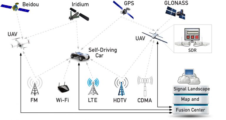
A schematic showing how Zak Kassas, assistant professor of electrical and computer engineering at UC Riverside, and his team are using existing communications signals to complement satellite-based navigation systems like GPS for the control of driverless cars and unmanned aerial vehicles (UAVs). Image: ASPIN Laboratory at UC Riverside
Instead of adding more internal sensors, Kassas and his team in UCR’s Autonomous Systems Perception, Intelligence, and Navigation (ASPIN) Laboratory have been developing autonomous vehicles that could tap into the hundreds of signals around us at any point in time, like cellular, radio, television, Wi-Fi, and other satellite signals.
In the research presented at the ION GNSS+ Conference, Kassas’ team showcased ongoing research that exploits these existing communications signals, called “signals of opportunity (SOP)” for navigation. The system can be used by itself, or, more likely, to supplement INS data in the event that GPS fails. The team’s end-to-end research approach includes theoretical analysis of SOPs in the environment, building specialized software-defined radios (SDRs) that will extract relevant timing and positioning information from SOPs, developing practical navigation algorithms, and finally testing the system on ground vehicles and unmanned drones.
“Autonomous vehicles will inevitably result in a socio-cultural revolution. My team is addressing the challenges associated with realizing practical, cost-effective, and trustworthy autonomous vehicles. Our overarching goal is to get these vehicles to operate with no human-in-the loop for prolonged periods of time, performing missions such as search, rescue, surveillance, mapping, farming, firefighting, package delivery, and transportation,” Kassas said.
In addition to Kassas, graduate students Joshua Morales, Joe Khalife, Kimia Shamaei, Jesse Garcia, and Sonya Ragothaman and undergraduate student Souradeep (Gogol) Bhattacharya contributed to this research, which was funded with support from the Office of Naval Research (ONR). Additional videos of the team’s research can be viewed on the ASPIN Laboratory’s YouTube page.
The UCR Office of Technology Commercialization has filed patents for the inventions above.
This article was originally published by UCR Today.
If you liked this article, you may also enjoy reading:
- Swarms of precision agriculture robots could help put food on the table
- Quadrotor automatically recovers from failure or aggressive launch, without GPS
- Robots Podcast #214: Project Ngulia: from Phone to Drone, with Fredrik Gustafsson
- Oxbotica’s autonomous vehicle software learns its environment and how it changes over time
See all the latest robotics news on Robohub, or sign up for our weekly newsletter.
tags: cx-Research-Innovation, drones, Flying, GPS, Mapping-Surveillance, Prototype, Research, Sensing, UAV