Robohub.org
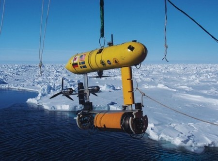
Antarctic sea ice mapping by underwater robot put to test | Gizmag

“Antarctic scientists have combined measurements provided by an underwater robot with existing satellite data to show that Antarctic sea ice may be thicker than previously thought. Their first-of-a-kind high-resolution 3D maps cover over 500,000 square meters (5.4 million sq ft) in the Weddell, Bellingshausen, and Wilkes Land sectors of Antarctica…”
Source: www.gizmag.com
See on Scoop.it – Cultibotics
John Payne
Related posts :
Robot Talk Episode 141 – Our relationship with robot swarms, with Razanne Abu-Aisheh
Robot Talk
23 Jan 2026
In the latest episode of the Robot Talk podcast, Claire chatted to Razanne Abu-Aisheh from the University of Bristol about how people feel about interacting with robot swarms.
Vine-inspired robotic gripper gently lifts heavy and fragile objects
MIT News
23 Jan 2026
The new design could be adapted to assist the elderly, sort warehouse products, or unload heavy cargo.
Robot Talk Episode 140 – Robot balance and agility, with Amir Patel
Robot Talk
16 Jan 2026
In the latest episode of the Robot Talk podcast, Claire chatted to Amir Patel from University College London about designing robots with the agility and manoeuvrability of a cheetah.
Taking humanoid soccer to the next level: An interview with RoboCup trustee Alessandra Rossi
AIhub and Lucy Smith
14 Jan 2026
Find out more about the forthcoming changes to the RoboCup soccer leagues.
Robots to navigate hiking trails
Christopher Tatsch
12 Jan 2026
Find out more about work presented at IROS 2025 on autonomous hiking trail navigation via semantic segmentation and geometric analysis.
Robot Talk Episode 139 – Advanced robot hearing, with Christine Evers
Robot Talk
09 Jan 2026
In the latest episode of the Robot Talk podcast, Claire chatted to Christine Evers from University of Southampton about helping robots understand the world around them through sound.
Meet the AI-powered robotic dog ready to help with emergency response
Texas A&M University
07 Jan 2026
Built by Texas A&M engineering students, this four-legged robot could be a powerful ally in search-and-rescue missions.
MIT engineers design an aerial microrobot that can fly as fast as a bumblebee
MIT News
31 Dec 2025
With insect-like speed and agility, the tiny robot could someday aid in search-and-rescue missions.


