Robohub.org
362
Precise Navigation using LEO Satellites with Tyler Reid
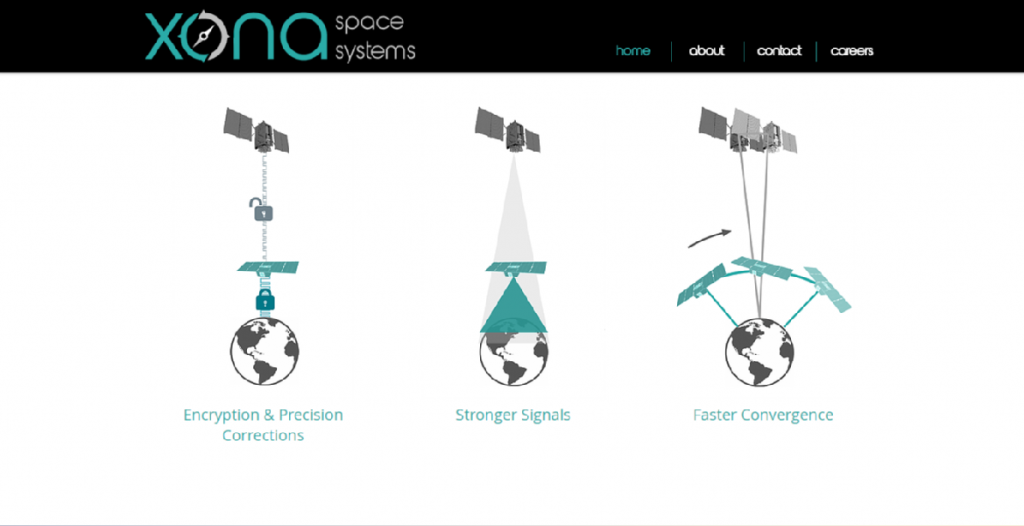
Dr. Tyler Reid, co-founder and CTO of Xona Space Systems, discusses a new type of global navigation satellite system (GNSS). Xona Space Systems plans to provide centimeter-level positioning accuracy and will serve the emerging autonomous vehicle community, where precise navigation is key. Reid discusses the advantages and technical challenges of a low Earth orbit (LEO) solution.
Tyler Reid
Tyler Reid is co-founder and CTO of Xona Space Systems. Previously, Tyler worked as a Research Engineer at the Ford Motor Company in localization and mapping for self-driving cars. He has also worked as an engineer at Google and as a lecturer at Stanford University, where he co-taught the GPS course. Tyler received his PhD (2017) and MSc (2012) in Aeronautics and Astronautics from Stanford and B.Eng. (’10) in Mechanical Engineering from McGill.
Links
- Download mp3
- Subscribe to Robohub using iTunes, RSS, or Spotify
- Support us on Patreon
lilly: Hello and welcome to the Robohub podcast. Would you mind introducing yourself?
Tyler: Hello and thanks again for having me on today. So I’m Tyler Reid and I’m co-founder and CTO of Xona Space Systems.
lilly: And can you tell us a little bit about Xona Space Systems?
Tyler: Yeah, for sure. So Xona Space Systems is a company focused on, basically building commercial GPS satellites.
So really moving away from the model of, you know, these kind of government operated systems like GPS that have a kind of very specific, you know, government oriented mission. Moving towards a system that’s, you know, commercially driven around kind of needs of commercial users and, you know, going more in that direction to sort of support those users going forward.
lilly: And what do you think are sort of the benefits of going commercial with a GPS type technology?
Tyler: Yeah, for sure. So to speak a little bit about my background and sort of where some of this is coming from. So, so I sort of came from the world of, you know, GPS and started really in grad school on that side of things.
And transitioned after grad school to working in kind of industry research. So I was working in autonomous vehicles, working with those systems and kind of seeing those systems really heavily rely on, on GPS and kind of what’s out there today. And really the state of the art of the technology was, you know, having third party companies basically deliver correction information for the GPS satellite.
So the information coming from GPS directly was really not quite at the level that it need to be to support these, you know, systems like self-driving that are really trying to get down to the centimeter level location to, to, you know, drive themselves on the road. and so to get to that level, you had kind of these companies whose whole kind of role was to deliver, you know, better orbit, better clock information than what GPS gives you directly to really drive those errors down to that kind of that centimeter level.
And because of the way the system was architected, which really wasn’t, you know, meant to be used this way, it led to. you know, the fragilities in that kind of signal. So when you start to drive under trees or in certain environments, you would often lose that kind of centimeter level location. And it just, it sort of left some, I guess, holes to be filled by, by something else.
And what that’s something else was was, was part of my job to figure out, okay. You know, was it maybe terrestrial based solution? Is it computer vision solution is a kind of all of the above. And, you know, with my background coming from, you know, satellite navigation and GPS and kind of seeing how these systems have supported, you know, some safety, critical applications like civil aviation, which is, you know, part of what my kind of, the thesis work was in and kind of thinking about how that could evolve to support, you know, some of these ground systems like autonomous vehicles, but also uAVs and, and kind of other sort of,sort of autonomous systems going forward, that sort of really led to this.
Okay, well, how can we change things on the space side rather than just trying to use what we have from these kind of government systems to, to sort of, you know, fill the gaps, I suppose. And so from a, from a commercial perspective, you know, what are some of the benefits that you get there? Well, really you’re not tied to kind of the, the system that, that the government provides for you, which, you know, is kind of static. It’s there for a reason. And it, you know, it’s really a fantastic system and it, it supports billions of users. It has created kind of all, you know, all these use cases that we, you know, I have, I have a terrible sense of direction.
So, you know, knowing kind of the blue dot to find my way home has, has been, you know, incredibly useful. But, you know, as we think about moving away from, you know, humans who can. use that information to sort of get close to where they need to go and then kind of finish the job themselves and, and going towards autonomous systems that really rely on that blue dot being, you know, exactly right where it is to, to, to really get to that point sort of on their own, without any input from, from any humans.
There really is sort of that there is sort of a leap that needs to happen there in terms of, you know, The kinds of levels of, reliability and also, you know, precision that, that those systems support. And so thinking about this from kind of the commercial perspective, you know, what can you provide and, and becoming kind of from an aerospace background, you know, how can you, you know, evolve this space segment to really be focused on the, on the commercial side.
And so. Some of the benefits. There is you, you just, you know, you have kind of a blank slate in a sense. And so you can start with, you know, what do we really need to support users on the ground? And then we can start to architect the system, you know, around some of those, you know, emerging needs rather than, you know, supporting things from in decades, in the past, I suppose.
lilly: And in terms of like getting to that centimeter level accuracy do you think that most of the technological advancements are in the space side or like, do you plan on doing does Xona space systems plan on doing a lot of that error correction, like similar error correction type stuff and like the full stack?
Tyler: Yeah, that’s a great question. And I’ll say in some sense, we’re not inventing, we’re not reinventing the wheel. We’re sort of, you know, we’re using a lot of the techniques that’s been well established by the sort of high precision GNSS industry, which has supported historically [00:05:00] things like surveying things like mapping, precision agriculture, you know, are big users of, of this kind of technology.
And so really kind of building on the shoulders of giants in, in that respect. You know, how, how are folks getting high precision today and kind of, you know, evolving that to kinda the next, the next kind of, you know, what might the next sort of, space infrastructure look like to, to use those techniques and kind of make them even better for folks.
And so, you know, when you look at the kind of errors that stack up in GPS, you’ve got. The atmosphere is a big one, you know, as those signals refract through the different layers of the atmosphere, particularly the ionosphere and troposphere, you know, that that’s a, an error that sort of manifests itself at the user level, but also just the orbit and clock information coming from the satellite, because ultimately you’re triangulating your position from, you know, a few different points in space.
You better know very well what those points were, cuz otherwise you’re not gonna know very well. What, what your position is at the end of the day. So you have to figure out a way to get, you know, centimeter level, you know, orbital information of the GPS satellite, so that you can in turn sort of get your position to the sort of centimeter level as well.
And so how do you do that with sort of, you know, as we think about this kind of evolving from, you know, the kind of, the techniques that have been used in the past to, you know, what might be possible, in the future? Well, it turns out that one of the big kind of inputs to that system, In terms of how quickly you can get from kind of meter level position down to kind of the centimeter level is how quickly the satellites move overhead.
And it turns out that if you make it such that the satellites move overhead very quickly, there’s just a lot more information in that sort of very quick pass than you have from these further satellites, which traditionally are kind of medium earth orbit to help that convergence get you from kind of a tens of minutes kind of place to a minute or less kind of place. And, and of course there are techniques that are making that always better all the time from a medium earth orbit perspective. You know, when you’re using kind of the traditional GSS satellites to, to get to that high precision, there are techniques evolving to, to get there faster and faster.
But if you have that very fast sort of motion across the sky, it just makes those techniques even better than that they would be otherwise. And so that’s, that’s, that’s an example of the kind of thing you can do from a, you know, commercial space segment perspective to, to just sort of bring more capability to, to folks on the ground.
lilly: And so if you have, if you get better performance from having moving vehicles, and so you’re having them at lower orbits, you also need like three or so to get your position does having more than that help? And how many, like how many total satellites do you think is gonna be the right amount?
Tyler: Yeah, that’s a really good question.
What it comes down to is, you know, the more satellites, the better , that’s kind of the simple question, the simple answer there, but mm-hmm, really we’re, you know, really leveraging a similar technique that’s been used from, from GPS, which is known as trilateration.. And what that is, is there’s basically four unknowns in that system and the four unknowns or your X, Y, Zed (or sorry, that’s Canadian – XYZ) and, and time, and, and the reason time is sort of an uncertainty there is that the way you calculate range to the different satellites is that the satellite sends a signal and the signal basically says it was this time when I sent it, the signal takes some time for it to travel to you. You receive it some time later.
And so the difference between the time it was sent and the time you received it is the, basically the time of flight of the signal. And, and that time multiplied by the speed of light is, is the range to the satellite. So, if you do that to several satellites, now you’ve calculated something that looks like a range to you because it’s, you know, that, that time of flight to a handful of satellites, you would think of, you know, in 3d space, you need, you have three satellites, three unknown, you know, XYZ position.
You know, what’s the, what’s that fourth unknown, you know, why do you have that extra unknown there? And that’s because you don’t know exactly what time it is when you received it, you received it at some local time, which is, you know, whatever time your phone says, but you know, how, how accurate is that at the end of the.
Tyler: And when you think of the sensitivity of the problem of how accurate you really need to know your time to do to calculate those ranges? Well, it turns out. One nanosecond of time, uncertainty is, is a foot or 30 centimeter. And so it stacks up very, very quickly when you’re talking about kind of nanosecond of, of time knowledge, and it’s very hard to, to maintain nanosecond sort of timing in your phone.
Your time, time in your phone is more at the kind of microsecond level. Most of the time, that’s kind of where it needs to be to, to do its job, which is kind of telecommunications and all this stuff. But if you’re talking about doing precision ranging. You really need that kind of nanosecond kind of capability.
And so rather than, you know, having to bring an atomic clock with you all the time to sort of keep your time at that sort of, you know, very high, precise level, you just solve for it instead. So you add a fourth satellite and now, you know, you get the three dimensions and that time dimension to, to get your position sort of down to, you know, our experience today is more kind of at that meter level, but you know, that sort of handful of nanosecond kind of uncertainty kind of point. And so, you know, going, so that kind of minimum number you need to get some kind of position information is, is four. It does assume you have no other [00:10:00] sensors or, or nothing else like that.
So if you just kind of only have your kind of GPS receiver and nothing else four satellites is kind of the bare number you need to, to get that first position. so you know, how many more do you need to do the job? Well, well, you want more than just four to kind of be robust to that. And, and the reason is, is you start sort of moving around in the world.
You, you may not always have foreign view if you kind of have, you’re assuming you have full view of the sky, all it takes is a building to block one part of the sky and you only have three. So you really wanna design that system to, you know, have more than four in view at all times that you were on earth.
So that you’re robust and things like buildings being in the way, trees being in the way. you know, also just, generally it’s, you know, you’re gonna have just something, that’s gonna give you higher precision if you have even more satellites in view, cause you have more measurements available to you and.
The the right kind of number that most, I guess I’ll say GNSS systems have come to today is more at that kind of 10 or 12 number of satellites in view. And that’s what GPS has today. That’s what the European Galileo system has today. And so kind of as well as the, the Russian, sorry, the Russian GLONASS, and Chinese Beidou systems are, are kind of in that similar number of satellites.
And so. Tenish or so satellite is about where you want be kind of at minimum and the more satellites you have to just better, it’s gonna work in more places, I guess.
lilly: Mm-hmm if it’s 10 or 12, like visible from your device at once, I assume they don’t have coverage of everywhere all at once for the full built out constellation.
Tyler: Yeah, that’s a great question. And so when, when you’re talking about kind of the GPS system, which is deployed in a medium Earth orbit, which is about 20,000 kilometer altitudeor so. That system has about 30 satellites to achieve that goal. So that’s about how many satellites that when you deploy sort of at the high orbit that you need. We’re targeting a lower orbit than that today, which is more kind of in the thousand kilometer range..
So, so being that 20 times closer to earth, it turns out that satellite footprint just shrinks and shrinks and shrinks. Cause you’re just so much closer to, to earth. And so you need more satellites to get the same amount of coverage. So we’re targeting about a 300 satellite constellation or so.
lilly: OK. speaking about the time of flight measurements, is there any, like, would you consider and what are the advantages and disadvantages of, instead of doing the one way time of flight and having to keep track of all that synchronization with doing sort of a two-way ranging, where your device is the one pinging?
Tyler: Yeah, that’s a great question. And, and this was one of the original trades that was done when folks were developing GPS. And so some people smarter than me had, had put a lot of thought into, you know, why you might. Do this kind of system over say this kind of two-way time transfer system.
Yeah. And some of the advantages there, the main one is really that if your device has to ping back to the satellite, it does two things and one of them is that it, it, it’s a bigger power draw on your device because your device is having to kind of send a radio signal that a satellite has to receive.
And so that that’s one piece. And the other piece of it is that the satellites then also have to, be able to receive all those signals from multiple users. And so you end up putting a constraint on the capacity of the satellite in the sense that now that satellite has to get pings back from all these folks that are using it, maybe only a few hundred or a few thousand people at once can use it, which is, it ends up being kind of a limiter on the number of folks who can actually use that system.
Whereas if you use this kind of one way time transfer system, where although you do need sort of an extra satellite in view to solve the problem. You can in theory sort of, you know, support an infinite number of users. And so, which is the case of GPS today, where we see it supporting, you know, billions of users and you can, you know, add as many devices as you want without having that constraint.
So that, that that’s the big one.
lilly: Yeah, that makes sense. So if you are at this lower orbit and GPS satellites, The traditional government funded ones still exist above you. Can you use them to better track your satellites?
Tyler: Yeah. absolutely. And that becomes one of the inputs, to the system, for sure.
Because, and folks have done a lot of stuff in, in low Earth orbit, supported by GPS because part of the service volume of, of those GPS is to support applications in lower orbit. So you can think of earth imagery, the international space station, all these kinds of folks are, are using that. That being said, we are designing the system to be GPS independent.
Just because there’s a lot of interest from that from folks to have that capability, you’re not necessarily fully dependent on, you know, this other system that you’re augmenting having some ability to sort of operate, without input from that system is, is advantageous in some ways, but it is there and it is a great input to the system that, that we’re putting together.
Tyler: And so it makes sense to, to include those measurements a way of just making the system more robust at the end of the day.
For a user, like for the average person with a phone, will the GPS receiver that I already have on my phone work with your system immediately? Or are there changes that have to be made?
Tyler: Yeah, that’s a really good question too. And it, there will likely have to be changes to, to the device in your phone today, but we see that as part of the sort of natural evolution of how the GNSS chip sets are evolving and. One of our, I guess our general approach to this is not to compete with the GNSS receiver manufacturers it’s to work with them, to incorporate [00:15:00] our service into their devices.
And, and so really working to, you know, make it, make that sort of adoption as similar to what say adding some of the new constellations that have come online over time is like, so, you know, originally there was only GPS chips and then there was GPS plus BLONASS chips, and then there GPS plus Galileo plus BLONASS plus Beidou chips.
And so really trying to sort. Continue that evolution of including some of these, these new systems into these chip sets. And so working with the, the GNSS receiver manufacturers for most likely the next generation of devices, because particularly the kind of ASIC devices that you find in your phone are, are so optimized for a specific application that fitting in new things is, is a big challenge. For some of the more, I’ll say, this, sort of, high performance receivers that are out there today that are supporting some of the high precision applications on that side of things, that there is some, possibility of, having that be more akin to a, a software update than,than sort of a new system.
lilly: Interesting. I wanted to pivot a little bit and talk more about, some of your work with autonomous vehicles and at like, there’s obviously a clear, like interface between these two things, but what are some of the similarities and differences in terms of like how you actually are solving technical problems or the autonomy on the vehicles and the autonomy on the satellites or any of that kind of thing?
Tyler: Yeah, that’s a great question. So I’ll say part, maybe I’ll, I’ll take. Give a little bit of history of sort of where some of the, I guess, sort of my time in autonomous vehicle sort of led to this interest in sort of pursuing this kind of satellite navigation side. so when I entered the kind of autonomous vehicle realm and I was working at Ford motor company at the time, part of my role at that at that time was sort of a combination of technology scouting and fundamental research .
In technology scouting, it was really working with the startups, particularly in Silicon valley, but also other technology companies as well, to really establish, you know, what is the state of the art in, you know, location and mapping technologies for. At first was, you know, focused on kind of these level four level five fully autonomous vehicles, but it was also sort of supporting some of the level two level three kind of, driver assistance systems as well.
And sort of once establishing that kind of where, what the state of they are, the technology was part of that and sort of, trying to identify which ones were some of the market leaders was to establish, you know, what are the requirements for these systems ultimately, and which one is kind of closest to where the requirements eventually need to be.
So, you know, what are the location requirements for, for autonomy? And that turned out to be a, a much harder question than I think we originally thought, I think folks were like, oh, you know, 10 centimeters seems to be the right number, but it was often kind of unjustified. It was sort of a 10 centimeter seems to be a number where the system fails the least.
So that seems like a good place to start. But we wanted to kind of take a step back and say, okay, fundamentally, you know, what do these vehicles really need in terms of, you know, a bounding box, if you wanna think of it that way around a vehicle to say, okay, this is the situational awareness that I need to do this, this kind of family of tasks or this kind of family of tasks.
And really what it turns into is there’s some applications where you need to know what road you’re on. Some applications you need to know what lane you’re in. And some applications we really need to know, you know, to the centimeter, to be able to steer the car within the lane and kind of, you know, get to where you’re going.
And it turned out that, you know, seeing kind of where, where the requirements ultimately needed to go and kind of where the state of the art technology was. There was at least in my mind, very much a gap of, you know, where, where things, sort of stood today. And that led to the motivation, at least from, from my side to say, okay, well, what is something we can do from the infrastructure side to help fill that gap?
Because one of the trends that was happening in the autonomous vehicle industry, at least in the time when I was, was there was. You know, the, the kind of number of sensors, the amount of compute on the vehicles was making those vehicles in some sense, prohibitively expensive. You know, you had so much hardware on the vehicles, the vehicles were kind of these kind of million dollar, very specialized kind of vehicles.
It just didn’t scale that well, whereas if you can offload some of that to the infrastructure side, to support lots of vehicles, You know, that seemed to make more sense to me at least. And, and so this went back to, okay, well, what, you know, being kind of someone from an aerospace background, position, navigation background, thinking, okay, well, what can we do from a space, infrastructure side to support this kind of position navigation and, and time problem.
Tyler: And so I think in terms of, you know, where these two things are, are sort of coming together is, is really seeing this from a okay, how can the, this infrastructure support the needs of those systems? There are, of course, some, some crossover between the two in the sense that there are technologies that are, I think gonna be used on both in the sense that, you know, you want those satellites when you’re deploying a large constellation to have, you know, a high degree of autonomy about themselves in terms of fault monitoring in terms of integrity monitoring.
Because ultimately you’re trying to. You know, support these, you know, safety, critical systems in the, in the case of automotive. And so having the, you know, a lot of that kind of fault checking, sort of done in an autonomous way. So that be caught very quickly, it becomes very important, but there’s also just fundamental things like, you know, fundamentally a vehicle when it’s doing its navigation and positioning is running [00:20:00] something like a Kalman filter or some something that is combining these measurements.
Those kinds of things are gonna be running on, on the satellites for orbit determination. So it’s a different context of problem, but you know, fundamentally a similar tool in, in the end of the day. And there’s also some elements of, I think, collaborative, you know, infrastructure as well. So when you think of, you know, self-driving car driving on its own with a whole bunch of sensors on it, well, that’s.
You’re kind of just trying to replace one human in a car. Maybe that’s not the best way to do it. Maybe there’s some advantages to having vehicles work together in a collaborative way where, you know, a vehicle that’s perhaps down the road from you can share sensor information or situational awareness information so that you can establish that situational awareness, you know, at the city level where you can see around corners, see aroundyou know, other obstacles that you can’t see to kind of get to the point where you’re driving as safely, as you know, all the humans combined on the road, rather than kind of just one human can only see one part of the view of the world. And so I think there’s an element of that that can find its way into the, the space kind of the space and kind of ground segments that support these kind of space systems going forward.
Y know, how can these systems work together to find faults in each other where you know, those, those kinds of ideas that I think are, are interesting as well.
lilly: Yeah. that’s a really good point. And I’m interested a little in hearing more about this idea of having the satellites collaborate and sort of what are the most technically challenging or technically promising elements of that.
Tyler: Yeah, that’s a great question as well. There’s, I’ll say there’s a lot happening in, in the space industry now, I think even compared to, you know, even five or 10 years ago that they really make a lot of this possible. And you know, one of the big ones is just the scale of the constellations being deployed these days.
And I think that that’s enabled by. A few things like the lower cost of access to space, you know, SpaceX is I think one of the more visible players there, but there are of course others and the other is just, you know, different satellite manufacturing techniques. So building satellites more like you would build a car on an assembly line rather than kind of these bespoke kind of one satellite’s in a room where you have a bunch of people kind of putting stuff on it.
It’s a pretty, it’s just a different model of, of assembling these things. And. When we look at the kinds of technologies that I think are, are sort of coming into that sort of satellite realm that are maybe even borrowed from places like automotive, where, you know, especially when you’re talking about assembly and, and testing, you know, making something that’s, you know, very robust in, in kind of high volumes that.
Sort of brings these things together. I think that, that that’s at least one example of, you know, I think where these two industries can learn from each other, I suppose. Uh, okay. So I think as far as, you know, autonomy on the satellites and the ability to sort of collaborate with each other, I think one of the big, the, one of the big components of that is the ability for the satellites to just talk to each other, to begin with. And so the ability to sort of pass information.
Between satellites is, is I think a, a big milestone sort of as part of that. And I think one of the enabling technologies there that we’re, that we’ve seen sort of come to light is the, this ability of kind of having inter satellite communication links between these satellites. And there’s been a lot of, I think advancement of in both optical and radio, kind of,you know, intersatellite links between that to pass that information around.
And I think that, that, I mean the first step to collaboration as it is an automotive as well, it’s just establishing I think that that’s standard and also the sort of ability for these things to pass information between each other. I think there’s certainly been challenges in automotive on that side with, with establishing standards, with things like vehicle-to-things, so V2 V to X, so vehicle -to-stuff, or other vehicle kind of communication links and establishing just, you know, what is the spectrum that we shared? What is the protocols for these kind of communications? And I think it’s, it’s one thing to do it in a kind of. You know, if one say automotive OEM decides to do it a certain way and they can do that between all their vehicles.
It’s another to do it sort of across vehicles of all different manufacturers, sort of in a standardized way. And so I think that that’s that’s one of the challenges is just sort of establishing, establishing sort of the technology and the kind of standards for that communication across, across satellites.
And of course, as we think about deploying our system, we think mostly of sort of communication between the satellites that we have. But it’s interesting to think about, you know, potential, you know, cross sort of, communication between other platforms as well.
lilly: Yeah. And do you plan on, do you anticipate having optical or RF cross links or both on your system?
Tyler: Yeah, I think that’s something that we’re exploring. So I think it’s something that’s on the table, but I think that we’re still in, we’re at the phase right now where we have deployed our first demonstration satellite. And so for the demonstration satellite, it has, I’ll say something that is akin to, you know, inter satellite link, which we’re exploring between this, our sort of second launch that’s coming, next year.
And so. That is something that we’re exploring as part of the long term deployment of the system, but the sort of earlier iterations may, it may not be required. So it’s, it’s something that we’re exploring and it’s something we’re keeping an eye on, but, it it’s maybe not necessarily something that’s fundamentally critical to the system operating.
lilly: Well, congratulations on your first launch and your upcoming second launch. I wanted to pivot a little bit more actually, and hear a bit about, some of your [00:25:00] research back when you were in the academia and like how that led into, both your autonomous vehicle and your current jobs.
Tyler: Yeah, that’s a, yeah, that brings me back
So to go back to, I guess my days as a grad student. So, the lab that I worked in was the GPS research lab at Stanford university. And it was a really great environment for me. It was one that focused, you know, very much on that kind of position navigation problem, but also one that focused a little bit on, you know, operational projects for the FAA, as well as we were working with the federal aviation administration.
You know, support these kind of safety, critical systems, you know, aircraft using GPS to land aircraft using GPS in flight. so, you know, thinking about problems about, you know, what are safety critical use cases of position navigation and time specifically in transportation. And in this case, it was supporting civil aviation.
And so that was a really, that was a really interesting environment for me, because you could see the work that you’re doing directly impacting that industry. In some number of years, it wasn’t that the grad students were working on things, you know, directly kind of in operation, but that it wasn’t too far away from kind of necessarily seeing the life of operation.
So I think from a, you know, how that led into kind of the, the work that I was doing, kind of in the autonomous vehicle world. I think that thinking about the problem of, you know, what are the kind of levels of situational awareness that vehicles need in terms of position navigation and time, you know, what is the level of kind of safety and integrity that those systems need?
Really using that kind of framework in a structured way to develop, you know, what might that framework look like in automotive, which was kind of new to that idea of having position and information as part of that kind of safety, critical input to, you know, steering the vehicle and, you know, kind of keeping the human partially in the loop or totally in the loop, which are kind of problems that aviation had sort of worked through because there are times where the aircraft will fly itself.
There are times where the aircraft kind of has the pilot in the. So it’s, you know, thinking about those kinds of problems in that framework. And I think that that, that kind of side of things directly led to the work that we did in sort of establishing, you know, what might be the framework and requirements for these vehicles going forward.
You know, thinking about this in kind of a civil aviation approach, because. And when you compare the numbers, you know, civil aviation really has the best track record that you can come up with in terms of safety and, you know, per miles traveled with humans and kind of all those by all metrics. It’s it’s way safer to sit at an airplane than it is to sit in a car that that was that’s generally the, the takeaway and part of that is the well that humans have a lot less humans in cars have a lot less training than humans in aircraft who are operating those things.
And so it’s a. That that’s just fundamentally one of those differences. And, and, and part of that is, is if something goes wrong in an aircraft, like you better know what to do quickly, whereas something goes wrong in a car, you can pull off to the side of the road. And so, and so just fundamentally some, some differences there, but I think that that’s, that’s one of the big ones I think was, you know, bringing some of that framework from, you know, aviation to automotive and thinking about those, those problems in that way.
And the other side of that was the kind of. You know, the kind of commercial GPS and GNSS side of that. So, you know, transitioning from, you know, You know, the government system that supports, you know, all these billions of devices and created all this kind of, you know, economic development and kind of all these advancements, and thinking about how that might evolve kind of in the so-called kind of new space age, which is the age when you think of things like SpaceX and, you know, these kind of players that have really challenged the sort of so-called traditional aerospace, which is, more the kind of, you know, when you think of that as kind of these longer timelines, very risk adverse kind of players. And, and, you know, thinking about how, how might some of these kind of new techniques or new approaches in space, thinking about these kind of mega constellations that are being proposed by, at the time they were being proposed, it did not yet exist. So we’re talking about kind of Starlink and OneWeb and you know, all these kind of players, which seemed kind of like science fiction at the time, this was kind of in the 2015 kind of era before a lot of this stuff launched anything or had been deployed.
These were all kind of ideas on. you know, some of that work was sort of the fundamental, okay, well, what might you be able to do with something like this? If, if these kind of satellites actually come to exist, if the launch costs actually come down, you know, what might be some capability that you could leverage from that kind of space infrastructure?
So if you could deploy something like that for position navigation and time, you know, what might that look like? What might the capabilities be? But I think at that point it was kind of a okay, well that, that’s an interesting problem, but, It was in some sense, lacking motivation. It was sort of a, okay, well, who wants this?
You know, what do we need this for? GPS works really well. Every, I think at the time it was like, well, we’ve done it. You know, GPS is in everyone’s pocket. What else could you want? And, and it wasn’t until I, I worked in an industry where GPS, as it stood, wasn’t quite enough for, for what they needed that I sort of those dots connected at at least on my side to, to see, okay, well maybe this kind of approach could support this other side as well.
So in some sense, you know, there’s, I guess learning from both sides and kind of connected these things together, I guess.
lilly: Yeah, that makes [00:30:00] sense. It’s very interesting to hear how it all connects. we are coming up on time, but I do have one last question. which is, are there other commercial players trying to get into the GNSS space?
Like, do you have any real competitors right now?
Tyler: Oh, there, sure. There’s definitely folks out there. So we’re not the only ones doing this. I think that they’re, I won’t name them all by name. Cause I, I can’t speak to everyone’s plans out there, but I can speak to a, a few general trends that, that we’ve seen.
And one is that, you know, the, the folks out there who are building these kind of mega constellations for communication purposes. So, you know, the internet from the sky kind of folks are definitely interested in providing something. I think that it, it looks very different from, from what we’re working towards, which is more of a , you know, specific high performance, you know, GNSS, P and T kind of service, which looks a lot like what you already have in your phone in terms of chip set, in terms of these kinds of, you know, antenna, these kinds of factors. When you look at some of the, you know, the communication, systems, you know, really they are a completely different frequency bands.
Their user terminals are usually pretty large because we need a pretty big antenna to sort of, complete the link budget to get the kind of data rates that they’re talking about. It, it they’re, they’re certainly thinking about it, but I think that, you know, their primary goal is really, you know, communication, but it’s sort of a, oh, we can, you know, we have this system, we can probably support some kind of navigation as well.
At least that’s what we’ve seen so far. So I think that that’s, that’s one of the competitors out there. In terms of others, we’ve seen some interesting stuff going on from actually one of the major, automotive OEMs out there, which is a Chinese company called Geely. They’re actually building and deploying their own constellation, which is really to support autonomous automotive activities. It’s, you know, communication navigation kind of all in one package. And so that’s, you know, appears to be, you know, one of the big, one of the big players out there. And so there there’s certainly some other companies as well. There are some established services out there today, for example, from Iridium, which is providing some P and T services today.
And there are other satellite services providing more correction services. So things that are correcting, providing additional information to sort of compliment the GPS signal, but not an additional, you know, sort of ranging or GPS signal itself. So that’s, I think one of the, one of the major differences there.
Tyler: So, and we, we, and I think since we’ve been doing this, we’ve seen some others, some other companies sort of propose some similar things as well. So I think we’re, it appears to be that, things are heading in this direction, I guess.
lilly: Well, yeah, it’s definitely an exciting space to be in an exciting time.
And. A really interesting idea. Thank you so much for speaking with me.
Tyler: Yeah, my pleasure. Thank you again for, for the invitation to speak here today. And, yeah, this was great discussion.
transcript
tags: Business, podcast, Robotics technology, Space, startup