
Robohub.org
Ten lessons for farm drones
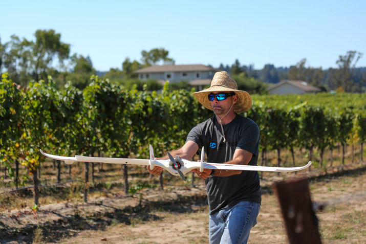
3D Robotics’s Vice President of Sales and Marketing John Cherbini prepares to launch a plane at Small Vines Wines in Sebastopol, Ca Sept. 13, 2013. The plane can help day-to-day operations on a farm via aerial imagery. Photo credit: Sally French, 3D Robotics.
Hear the word “drone” today and you’ll probably picture some kind of flying weapon, snooping or raining Hellfire missiles from above. But in reality, the first drones you’re likely to see actually in use are more likely to be closer to crop dusters, buzzing over farms. Rather than taking pictures and videos of people, they’ll be surveying fields, using their high-resolution sensors to improve crop yield and decrease agricultural water and chemical use.
Why farms? Because agriculture is a big data problem without the big data . About half of the “inputs” in farming (from fluids to pesticides, fungicides and herbicides) are typically wasted because they’re applied in greater amount than needed or in the wrong place, such as the ground between plants rather than the plants themselves. That’s considered unavoidable, due to the nature of spray application or the need to avoid under-use of water and chemicals, which can be catastrophic, from disease outbreak to total crop loss.
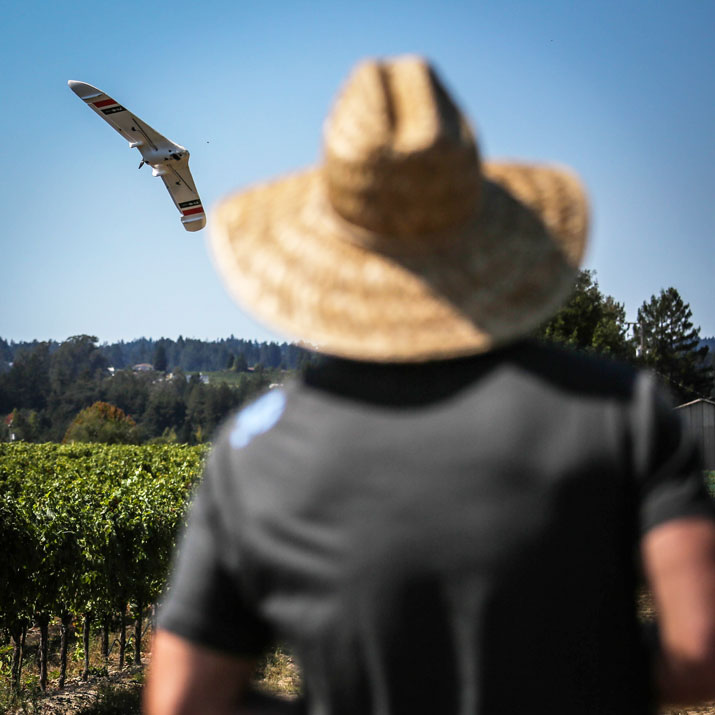
Cherbini watches as a plane, manufactured by 3D Robotics, completes a fully autonomous mission over a field in Sebastopol, Ca. Sept. 13, 2013. Since harvest times at vineyards can be short, the ability to have a plane like this is a tool for farms to generate frequent and accurate imagery. Photo credit: Sally French, 3D Robotics.
Soon farmers will know what’s going on with every plant, spotting problems before they spread, and applying chemicals with honeybee precision. They’ll use pesticides and fungicides only when needed and in the smallest amounts necessary, lowering the chemical load in both food and environment and saving money. On a small farm, you can get that level of precision with hand-tending. But on a big farm, the answer is more likely to be robotics, including flying robots — drones.
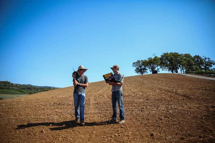
Cherbini, and Brandon Basso (Senior Research and Development Engineer at 3D Robotics) wait for their plane to complete a preset, autonomous mission at Kunde Family Estate in Kenwood Ca. Sept. 13, 2013. The plane will capture images that the farmer can use to inspect his land. Photo credit: Sally French, 3D Robotics.
For the past year, my team at 3D Robotics has been flying our drones on farms, gathering data and talking to farmers about what they want and how they work. These are some of the lessons we’ve learned:
- Every crop is different! It goes without saying, but grapes are not tomatoes, and tomatoes are not corn. There are hundreds of different kinds of farms, ranging from trees to roots (and that’s not even including livestock and ranching). Each crop needs to be measured differently to generate actionable data. There is no universal crop survey solution, and it will probably be specialists in each particular crop type who ultimately deliver solutions to farmers.
- Multicopters, not planes. We started with fixed-wing UAVs, but quickly realized that most farms don’t have landing strips. Even short takeoff-and-landing planes get battered fast in regular use without dedicated landing areas, which few farms have. Meanwhile, multicopters, which can take off and land anywhere, are gaining endurance and can now fly for as much as 40 minutes and cover miles. Planes are only suited for the largest farms, and even then missions need to be planned very carefully to find places they can reliably land.
- Phones/tablets, not laptops. Farmers don’t want to drag laptops into the fields. Any drone that is expected to be used by regular consumers should be entirely operated by a standard Apple or Android smartphone or tablet.
- One-click auto missions, not “flying”. Likewise, farmers don’t want to have to fly things . Agricultural UAVs should be fully-autonomous, from takeoff to landing. The experience should be as simple as pressing a “Start” button on a phone and the drone flies the entire mission on its own.
- Fly the camera, not the aircraft: What the farmer is interested in is a picture — not the acquisition of the picture. Let sophisticated planning tools figure out precisely how to gather the right images, let autonomy take care of the nitty gritty details of flight dynamics, and let humans do what humans do best — specify high-level desires.
- Video can be worth more than stills. Don’t discount how good farmers are at spotting things with their own eyes. Sometimes a first-person-view live video feed will allow them to spot issues and direct the vehicle to more closely inspect the problem area. (Needless to say, this is only really practical with multicopters). Indeed, farmers may not even know what they’re looking for initially. Sometimes general situational awareness is the task, rather than delivering a specific data product (such as a mosaic).
- NDVI is surprisingly easy to do. The gold standard of crop surveying is a “Normalized Differential Vegetation Index”, which shows the difference between regular red light reflected from plants and near-infrared light. Healthy chlorophyll absorbs red and reflects near-IR, while damaged chlorophyll reflect both. It doesn’t take expensive cameras to gather this data. A regular camera slightly modified with a blue bit of plastic becomes a near-IR camera. Take a cheap consumer 3D camera with two lenses, modify one for near-IR, and you’ve got a NDVI camera for less than $200.
- Aim for crop consultants, not farmers. Most crop data services are provided by local consultants, such as agronomists, not the farmers themselves. At the moment, FAA regulations ban most commercial use of UAVs, defined as anything where money changes hands, so most are used by farmers themselves for their own purposes on their own land. But Congress has mandated that the FAA introduce regulations to allow wider commercial use by 2015 (although it will probably be later than that before this happens). At that point, expect most users to be those local service providers, not the farmers themselves.
- Time is money. Drones can get answers fast and cheaply, taking advantage of their “anywhere, anytime access to the sky” abilities. That means “timely data on time”, such as daily surveys to find exactly the right time to harvest. Likewise, changes over time can be equally illuminating. The aim of crop surveying is to show the farmers something they can’t see with their own eyes, and the time dimension is a great example of that. By doing regular crop surveys, say every day or week, and using software to highlight differences over time, it’s possible to zero in on growing differences between areas of a field, which may be directly correlated to productivity.
- Data can be marketing. Some seed companies already offer to do aerial crop surveys for free as part of a sales process, much as they once “walked the field” as part of a free crop analysis process. Similarly, crop survey data can do more than simply guide a farmer into making different crop management decisions. It can also allow the farmer to market their harvest more effectively, pitching such high-tech precision agriculture as a differentiating quality in a commodity field. If data-driven crop management lead farmers to use less chemicals and water, perhaps someday “drone-guided agricultural” will be something consumers could be willing to pay more for. Done right, big data agriculture means “greener” crops and food. If consumers will pay a premium for organic, why not for this?
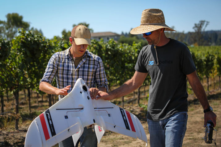
Cherbini (right) and Basso (left) inspect their plane after it completed a fully autonomous mission over a field in Sebastopol, Ca. Sept. 13, 2013. Photo credit: Sally French, 3D Robotics.
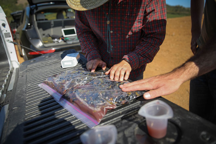
Viticulturist Ryan Kunde prepares to crush grapes in a plastic bag from one of his fields at Kunde Family Estate in Kenwood, Ca. Sept. 13, 2013. Kunde was able to tell which grapes needed to be harvested based on aerial images generated by a drone created by 3D Robotics. Photo credit: Sally French, 3D Robotics.
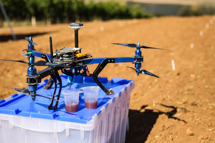
Engineers at 3D Robotics used their Y6 multicopter to fly over vineyards at Kunde Family Estate in Kenwood, Ca. Sept. 13, 2013. The copter is able to collect images that show rapid, on-the-spot analysis of ripeness. Photo credit: Sally French, 3D Robotics.
If you liked this article, you may also be interested in:
- Snap 2014: Aerial drones and 3D mapping software for civil engineering surveying
- Down on the farm with drones
- Matching technology to value creation: Drones in agriculture
- UAV innovation is in the Cloud; 3 precision Ag innovations to watch for in 2014
See all the latest robotics news on Robohub, or sign up for our weekly newsletter.
tags: 3D Robotics, cx-Aerial, Environment-Agriculture, Mapping-Surveillance, robohub focus on agricultural robotics

AUAI is supported by:


